
Walk an Avon Street by Address
A street search begins with the exact delivery form, then turns that address into land-record keys. In Avon, the county parcel map identifies the lot and owner of record. Doxpop follows the owner and legal description into recorded instruments. Election records and old directories add limited person clues, but they follow separate access rules. Keep each statement tied to its source.
- Verify the number, direction, suffix, city, state, and ZIP with the USPS address tool.
- Search Beacon, select the parcel polygon, and save the parcel ID, situs field, district, and legal description.
- Open nearby polygons to build the street segment by parcel, not by guesswork from a postal list.
- Search the owner in Doxpop, match the deed by legal description, and work back through grantors and grantees.
- Use lawful voter access and local criss-cross sources as added evidence, then verify with the custodian.
This order keeps the Avon address search grounded in facts and exposes conflicts between tax, postal, and map fields.
Search Avon Streets in Beacon
Hendricks County Beacon is the current parcel and GIS route. Search one street number first. A selected parcel may show owner, mailing and property addresses, parcel and alternate IDs, section-township-range, class, acreage, district, a brief tax description, assessment facts, and the polygon on the county map. That record identifies the owner shown on the roll. It does not name every current occupant.
| County search control | Input | Required | Local behavior |
|---|---|---|---|
| Owner last name | Text | No | Enter last name first with no comma; partial text and deed spelling help |
| Owner first name | Text | No | Use after a broad last-name search |
| Prior owners | Legacy checkbox | No | Can extend the historical name trail |
| Address or city | Text | No | More text narrows; omit direction or suffix when wording varies |
| Tax ID or State ID | Exact text | No | Needs the full number and gives the strongest cross-system key |
The county's retained legacy instructions explain these local rules even though current searches route to Beacon and LOW Tax Info.
Map an Entire Avon Street
A whole road cannot be built from one result. If the assessor interface accepts a street name alone, review each returned number and check for missing directions or suffixes. Otherwise, pan Beacon along the road. Select each parcel polygon and record its situs number, parcel ID, legal description, and map position. Mark lots across the road separately from lots that share a boundary.
The official county brochure visibly supports aerial imagery, parcel boundaries, street labels, parcel IDs, and a selected property record. Do not assume every layer seen in another county exists here. For an Avon by-street search, the outline and legal description keep the chain tied to the right land.
The Beacon parcel viewer screen shows the map-based start.
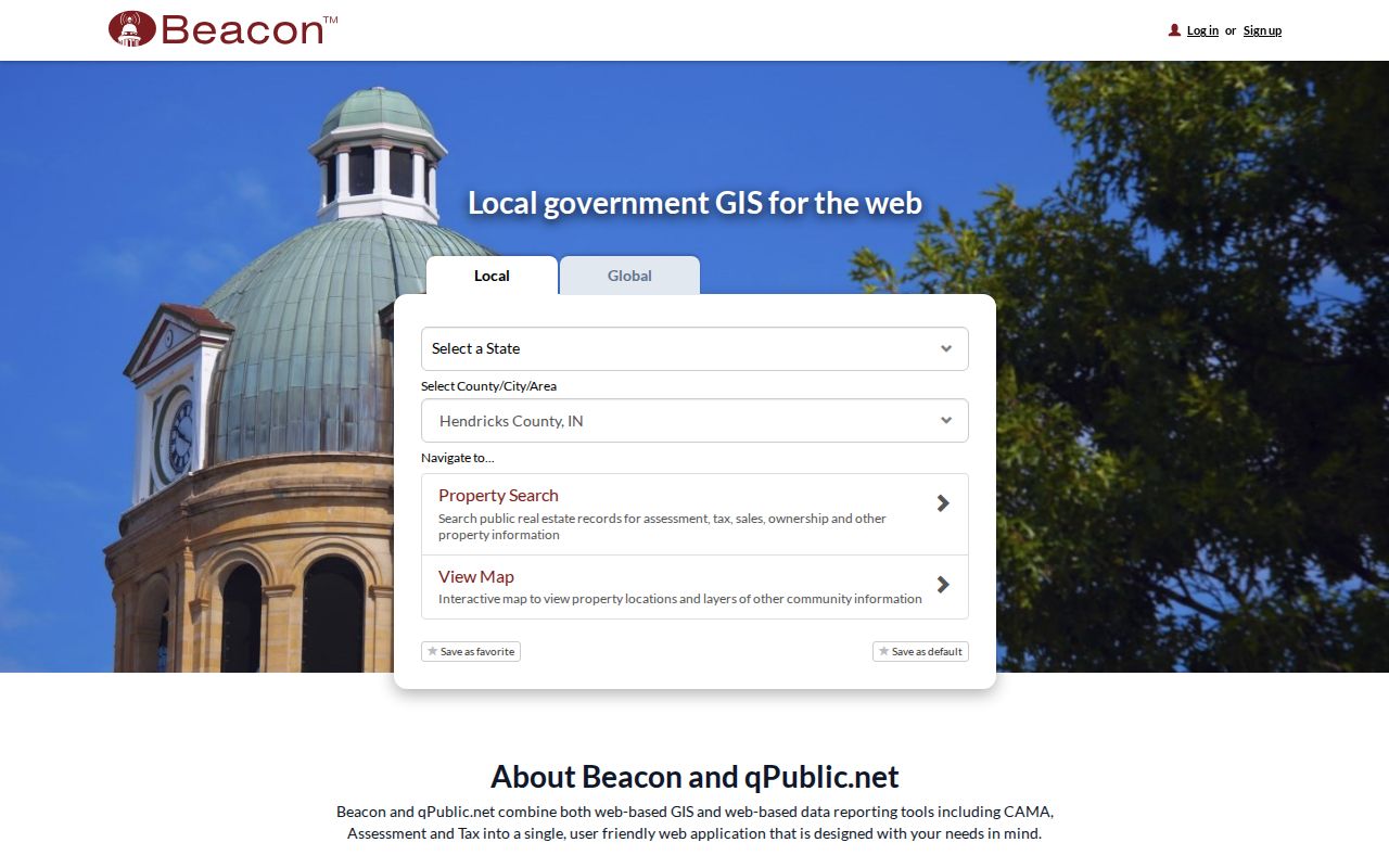
Open one polygon at a time, then copy the county identifiers before moving to the next lot.
Avon Situs and Mailing Addresses
The situs address marks the taxed site. The mailing address is where tax notices go. USPS city and ZIP describe mail delivery. Those fields may match, but Hendricks County says a parcel in an Avon taxing district can carry a Plainfield mailing city. It also warns that mail city is not the same as taxing city.
- Parcel
- A mapped unit of land with its own county identifier.
- Situs address
- The street location assigned to the taxed parcel or structure.
- Plat
- A recorded map that divides land into lots, blocks, roads, or easements.
- Criss-cross directory
- A historical directory arranged by street and number rather than by surname.
Copy all address forms exactly. If systems disagree, use the parcel polygon and legal description to identify the land. USPS confirms a delivery form, not a person, owner, or town boundary.
Avon Street Directory Record Layers
Address-keyed sources cover different parts of a street's story. The parcel roll is current. Deeds and transfer cards reach back. Town permit files document work at a location. Voter data follow a controlled election process rather than an open road roster.
| Avon address layer | Key facts | Keeper and span | Best route |
|---|---|---|---|
| Parcel and tax roll | Owner, situs, mailing address, ID | Hendricks Assessor and Treasurer, current | Beacon, LOW Tax Info, office |
| Recorded instruments | Party, date, type, legal description | Recorder; index from 1964, images from 1975 | Doxpop, counter, phone, mail |
| Transfer cards | Prior owner, area, key, transfer facts | Archive; yellow 1941-1972, blue 1989-2004 | Area and name indexes |
| Maps and plats | Road, lot, block, boundary | Maps from 1865, plats from 1880 | Archive, Recorder, State Library |
| Town work files | Address, project, dates, plans | Town of Avon | iWorQ, form, APRA request |
| Voter records | Registration facts or approved list scope | State and county elections | Portal or county request |
Move by the strongest shared key. Parcel ID links map, assessment, and card. Legal description links the parcel to a deed and plat. Exact address and dates make a Town request practical.
Follow Avon Deeds Along a Block
The Recorder index is built around parties, document facts, and legal descriptions, not a dependable modern street field. Start with the owner shown by Beacon. In Doxpop Recorded Documents, select Hendricks County and search that person or entity as a party. The public form also provides Super Search, while advanced controls separate party name, legal description, and document information.
A result can show document details, county, recording date, instrument type, and party. Open the matching purchase deed and record grantor, grantee, date, number, legal description, and image state. Search the seller as a grantee in an earlier deed. Across several Avon parcels, shared subdivision or plat text can reveal that a block was laid out or transferred as one phase.
The Hendricks deed-search screen illustrates the party-first route.
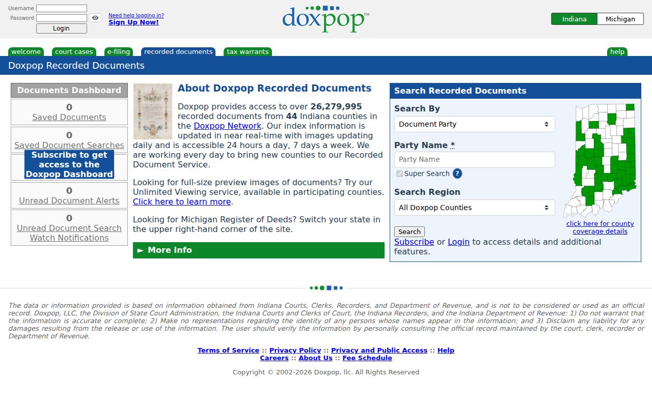
For an official image or certified copy, use the Recorder in Danville or call 317-745-9224.
Older Avon Street Directory Bridges
Doxpop's Hendricks index begins in January 1964, but scanned images begin in January 1975. An instrument may have public index text without an online image. Before 1964, move to general grantor and grantee indexes, deed books, auditor transfer books, State Library microfilm, FamilySearch, plats, and archive scans. Yellow property cards cover 1941 through 1972. Blue cards cover 1989 through 2004.
The official State Library guide does not list an Avon-specific printed run. It lists selected Robinson's directories for Danville and Plainfield from 1960 through 1990 and a county farmer directory from 1920. Ask the Huron Heritage Room about telephone books, donated community books, school material, or a reverse volume. The Avon city directory collection notes explain those holdings without turning this street workflow into a full shelf survey.
Note: Doxpop identifies its database as an index aid, so verify a decisive deed or image with the Hendricks County Recorder.
SR 267 in Avon Street Records
Avon's official history gives a key road-name variant: State Road 267 is now Avon Avenue. An old map, deed clue, directory line, school paper, or address record may use SR 267 while Beacon or a current Town page uses Avon Avenue. Search both forms. Also test rural route, township, subdivision, and postal labels when a modern street number produces no old match.
No official source located a town-wide house-number change with a verified date, so no by-address search should claim one. A failed number search should lead back to the plat, lot, parcel legal description, section-township-range, adjacent owner, and old road name. Avon incorporated in 1995, which helps explain why much older material may identify the area without the current town label.
Avon Permits by Street Address
Avon's iWorQ portal handles fence, sign, building, right-of-way, driveway, reroof, and deck requests. A known request number can return status. The detailed right-of-way form asks for the work address or nearest intersection, contact details, work type, lineal feet, start and completion dates, fee, bond, map, and traffic-plan material.
The Avon right-of-way form shows the address fields that make one street request precise.
Code Enforcement says a complaint is investigated within two business days and can move through notice, correction, ticket, or legal steps. No public universal case register was found. Ask the Clerk-Treasurer for disclosable permit, inspection, notice, or right-of-way records at an exact address and within a date range.
Avon Voter Data by Street
The Indiana voter portal does not provide an unrestricted list of all voters on an Avon road. It validates a submitted registration search and supplies polling, ballot, provisional-status, and county contact facts. Indiana law allows inspection or copying of certain registration material, but protected categories, identifying numbers, and Address Confidentiality Program records remain outside public view.
The VRG-24 form can request voter registration, vote history, or a walking list at county, township, or precinct scope when the requester meets the form's category and use terms. Hendricks County policy controls approval and fees. That route may add lawful election data to a road search, but it does not justify publishing a guessed roster. A focused request should state the address, person, precinct if known, and date range.
Limits of an Avon Street Directory
A parcel owner is not always an occupant. A mailing address may be elsewhere. A deed can be current while a household changes, and a directory entry can lag a move. Utility account details are not an open Town directory. Driver and vehicle personal data are restricted. Protected voter addresses, sealed cases, juvenile records, and other confidential fields do not become public because a street is known.
Use the street directory to document public links among an address, parcel, owner of record, deed, map, permit, and historical source. Label inferences as inferences. When the goal shifts from a road to one named person, verify the same-name match with a date, relative, parcel, or case number.
Lawful personal use. Avon address records support family, property, estate, and civic research. Never use a street record to stalk, harass, threaten, or harm anyone.